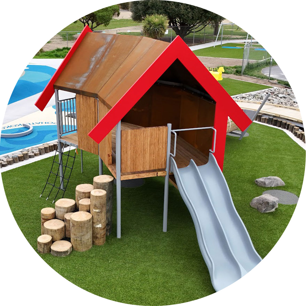
We are told, one of the most meaningful types of play, is when kids play with their imaginations, they lead the story and a trusted adult shares the fun with them. So it was important to CPlay to make sure all ages, abilities and sizes could play together, and be inspired to play with their imaginations. Added bonus was if the play connects to history, culture, heritage, stories and geology of our area, so we can learn where we come from, better understand who we are, and make good choices into the future. Here are some of the stories that have inspired the playground.

CPlay Playground opened 6 Dec 2023. The two-meter-high black frames weere installed to feature art and artifacts on information and stories that helped inspire the playground design - photo Geoff Cloake
What better place to start our story than with a creation story... the first shipwreck!
Rock art reproduction on the wall of the shelter at the Caroline Bay Playground in Timaru. The shelter was designed by John Rushton and the project was championed by the Timaru Suburban Lions Club. The rock are is near the entrance of the playground, and is a perfect place to start the playground experience - with a creation story and rock art. - Photo Roselyn Fauth

Piece of rock art on display at the Te Ana Māori Rock Art Centre in Timaru. Photograph by Geoff Cloake. Image used with the permission from Te Ana Ngāi Tahu Māori Rock Art Centre and Te Rūnanga o Moeraki.
There are over 500 Māori rock art images nearby. The meaning and function have been lost over time, so we are left as viewers to interpret the art.
Some say this image could depict a creation story of an ancestral waka, the Ārai-te-uru which sailed past what is now known as Te Tihi-o-Maru (Timaru), down the coast and capsized near Matakaea (Shag Point).
Many of the passengers went ashore to explore the land and did not make it back to the waka before daylight. Instead they turned into many of the landmarks of Te Waipounamu (South Island).
Aoraki (Mount Cook) is at the centre of the Ngāi Tahu creation traditions of Te Waipounamu (South Island).
Aoraki (Cloud in the Sky) is on his grandfather Kirikirikatata shoulders. Pātītī (Patiti Point) and Tarahaoa and Hua-te-kerekere (Big Mount Peel and Little Mount Peel) were also passengers. This is why Aotearoa (New Zealand) maunga (mountains) are sacred.
This piece of rock art was removed from Takiroa (Waitaki Valley) and is on display at Te Ana Māori Rock Art Centre. The rock art was photographed and reproduced with the permission of Te Rūnanga o Moeraki, Arowhenua and Waihao.
Please do not reproduce this rock art image without permission.
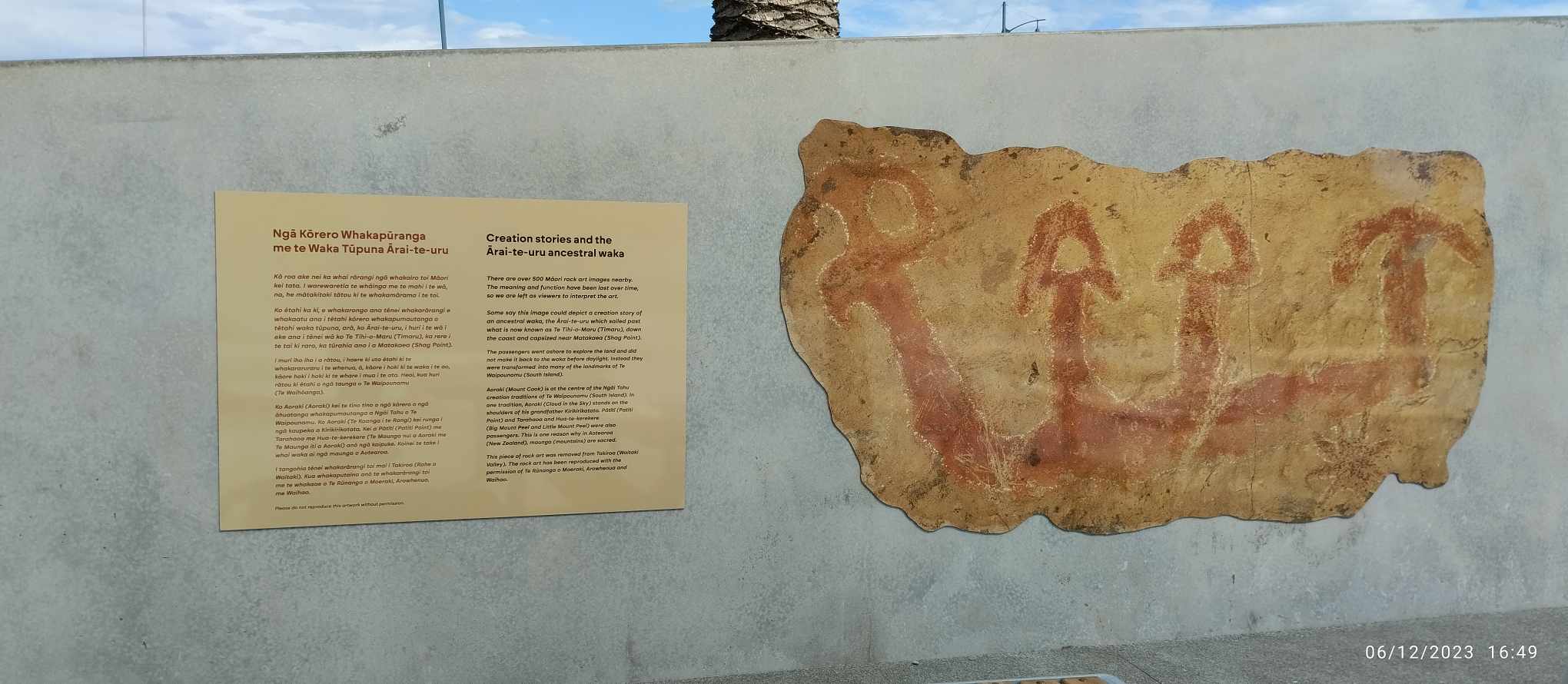
Rock art reproduction on the wall of the shelter at the Caroline Bay Playground in Timaru. - Photo Francine Spencer

Aoraki/Mount Cook, mountain, the highest in New Zealand, located in the Southern Alps/Ka Tiritiri o te Moana, west-central South Island. It reaches an altitude of 3,724 metres (12,218 feet) – high enough to be permanently covered in snow. - Photo Geoff Cloake
Read more: Creation Stories and the Ārai-te-uru Ancestral Waka

View north up the Timaru District coastline showing an interruption by the Timaru basalt formation. It forms the first hill south of the Canterbury Plains where Timaru's Hilton Highway ends (named after Timaru's first woman Mayor of Timaru City 1959-62). Photography courtesy of Geoff Cloake 2012.
2.5 Million years ago, lava flowed like fingers from the Waipouri / MtHorrible area to what is now the coastline of Te-Tihi-Omarua Timaru.
This is the most recent volcanic activity in the South Island and is believed to be dormant.
It was formed in a single event, which is an uncommon characteristic of volcanic systems.
Rather than a big cone shape volcano, Waipouri (Mt Horrible) was more like a line of fishers.
The lava flowed down a slope. The sea was probably nowhere near the erupting lava but has advanced occasionally, eroding the basalt and helping to form the current coastline.
Waipouri (Mt Horrible) to the sea and helped form the terrain, reefs and wetlands of Te Tihi o Maru's coastline.
Today you can see the lava as an “apron” at the foot of Dashing Rocks. The basalt below the Benvenue was quarried and placed there to mitigate erosion.
Basalt was used as a construction material and the “blue stone” blocks can be seen in many of Timaru’s heritage buildings, homes, bridges.
The rock was also quarried to help construct Timaru’s artificial harbour.
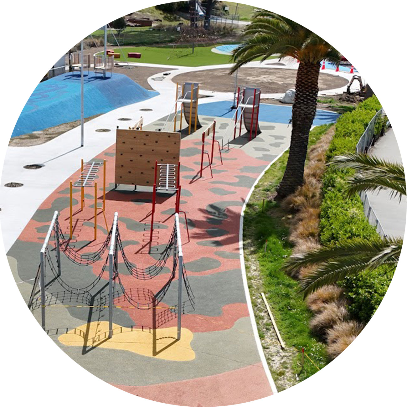
CPlay's "Floor Is Lava" obstical course. For some friendly competition two people could race each other by starting at the ninja wall going down one side of the course and running back up the other side to race up the catch the flag 4m high pole. For an easier challenge you could trying moving up and down the course by only stepping on rock to avoid the lava. - South Canterbury Drone Photography
Read more: Ancient Lava Flowed Here Helping to Create Timaru’s Hills and Reefs
Loess (wind-blown silt from the mountains) was deposited 9000-11,000 years ago. This was when the Canterbury Plains were covered in glaciers, and the last ice-age began disappearing.
As the glaciers retreated, they left behind a layer of gravel and sand. Strong winds blowing across the plains, picked up the fine sediment and deposited it on the lee side of hills and mountains, forming the loess cliffs.
The amateur Timaru geographer John Hardcastle realised in the 1890s that the loess cliffs of Timaru were like a time-line of past climates. He wrote a scientific paper about it. This became an important document world wide and is still used, to better understand our changing climate. This information could also help develop models to predict future climate change.
The characteristics of the loess layers, such as thickness, grain size, and mineral content, can provide information about past wind and climate conditions.
The loess is over 20 meters thick in some places and is one of the thickest and most extensive deposits of its kind in the world.
The loess is found all over Timaru and was used for making bricks for Timaru’s construction.


Loess layers at Dashing Rocks - South Canterbury Drone Photography

Loess layers at Benvenue Cliffs - South Canterbury Drone Photography


Tuna (eel) are a very significant, widely-valued, heavily-exploited, culturally iconic mahinga kai resource. - Geoff Cloake
Timaru’s coastline was abundant in marine life and was an important source of kai moana for Māori.
Kai such as tuna (eel) and inaka (whitebait) patete (fish), and kōareare (the edible rhizome of raupō) were abundant in the area.
Mahika kai (to work the food)
relates to the traditional value of food resources and their ecosystems, as well as the practices involved in producing, procuring, and protecting these resources.
Te Rūnanga o Arowhenua is the principal Māori kainga in the Aoraki region from the Rakaia to the Waitaki and back to the main divide. They are one of the 18 Paptipu Rūnanga that are leaders amongst their southern communities and are based with the marae in South Canterbury.
They primarily claim descent from the hapu Kāti Huirapa and affiliate to the iwi Waitaha, Rapuwai, Kāti Hawea, Kāti Mamoe and Ngāi Tahu.
The ancestors of the Arowhenua people were well established between the Rakaia river to the north, Waitaki to the south, and back to the central mountain ranges of Aoraki and his brothers (Southern Alps).
Prominent Huirapa ancestors, trading trails, settlements and events extend beyond these areas, but the local region isthe most concentrated signs of activity and occupation of Rapuwai, Waitaha, Kāti Hawea, Kāti Mamoe, and Kāi Tahu.
The many lakes, rivers, and corridors of native bush provided rich hunting and gathering grounds, with a long established cycle of gathering, travelling and trading was prevalent into the late 1800’s.
Some of the earliest signs of occupation in the region are the many rock art sites throughout South Canterbury.




LEFT An early map of Timaru in 1860. RIGHT zoomed in area showing the labeled area "Pohatu Koko" next to the "old whaling station". This is where the traffic lights are at the end of Wai-iti Rd, and Evans St. The stream running through the area can be seen above. This stream is now piped under the viaduct at the bottom of Wai-iti Rd, under the playground and out sea at the Benvenue end of the boardwalk.
Courtesy of the National Library. Archives New Zealand/Te Rua Mahara o te Kāwanatanga. Christchurch Office. Archives reference: CH1031, BM 245 pt 2, R22668176


Section on the map showing the Pohatu-koko stream.

Whales Creek Railway Viaduct at the foot of Wai-iti Rd and Evans Street, Timaru, New Zealand, 1904-1915, Timaru, by Muir & Moodie. Purchased 1998 with New Zealand Lottery Grants Board funds. Te Papa (PS.001051)
1947 - View to the south Canterbury town of Timaru with Caroline Bay with Evans Street in foreground looking south over the CBD and outer suburbs. You can see the stream running to the sea. Aerial photograph taken by Whites Aviation. Tiaki IRN: 720135. Tiaki Reference Number:: WA-06402-F - PA-Group-00080: Whites Aviation Ltd: Photographs

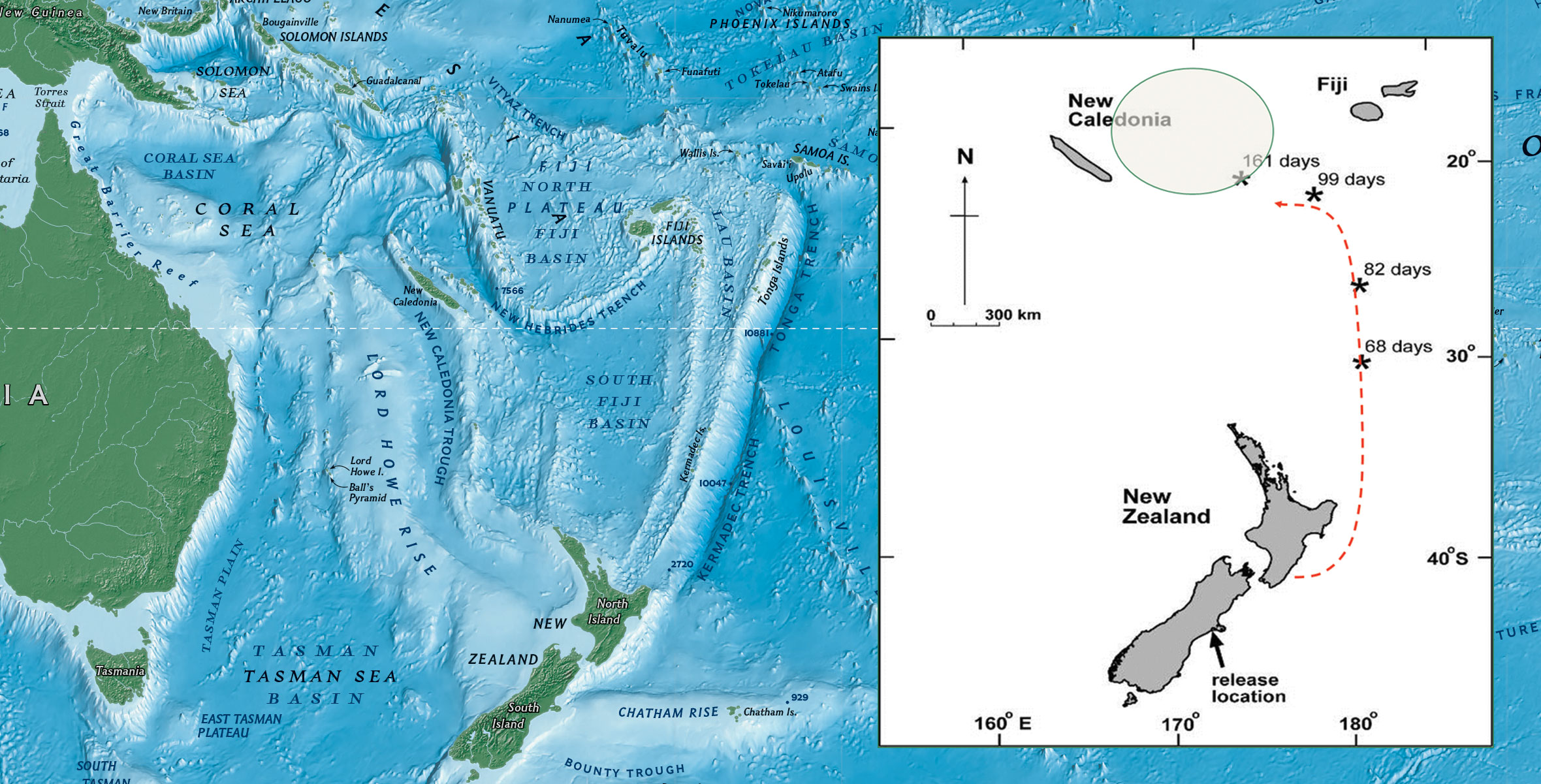
The tuna go on a massive migration journey from New Zealand to the Kemadec Trench near Tonga. They produce eggs which float back to the shores of New Zealand. Adult freshwater (living in streams, lakes, wetlands) can live up to 100 year old. They feed on insects, snails, fish, and even birds. Female tuna can reach 2 meters long. They leave their home and migrate thousands of kilometres from the fresh water to the sea water into the Pacific Ocean to release eggs and sperm in a process called spawning. Their eggs hatch far in the South Pacific Ocean near Tonga. They are very small and can only be seen using a microscope. The fertilised eggs then develop into larvae called leptocephali, which travel back to New Zealand drifting via ocean currents over 9-12 months and eventually arrive in New Zealand. Eels then enter our rivers as small juveniles that are known as glass eels. They are about 60-75 mm long. After several weeks in the fresh water the darken an become known as an elver. They migrate upstream during the summer. They are able to climb obstacles until they get to 120mm length.
Read more: The Reefs were Abundant in Marine Life - An Important Food Source for Māori

Moa footprints produced from actual scans of a moa footprint found south of Caroline Bay at Pareora. - Photo Roselyn Fauth

"It was near this point in 1889 that bones of the moa species Anomalopteryx Didiformis were discovered during quarrying operations. The bones could be as old as 2.4 million years and maybe the oldest yet found in NA. The species of moa was relatively small at around 1 metre in height and is generally thought to have occurred in upload areas or at lower altitudes during the ice ages." - Photo Roselyn Fauth
Moa were large, plant-eating birds that once roamed the entirety of Aotearoa New Zealand.
Kai such as tuna (eel) and inaka (whitebait) patete (fish), and kōareare (the edible rhizome of raupō) were abundant in the area.
Mahika kai literally means 'to work the food' and relates to the traditional value of food resources and their ecosystems, as well as the practices involved in producing, procuring, and protecting these resources. LEFT Tuna (eel) on display at the South Canterbury Museum. RIGHT Mōkihi display at Te Ana Ngāi Tahu Māori Rock Art Centre.
Caroline Bay was part of the seasonal food gathering journey for local Māori, and there are over 500 rock art images in South Canterbury created by their ancestors. Some of these could depict waka and mokahi used to journey the sea and rivers.
Read more: Giant Extinct Moa used to live in South Canterbury

"70 tun was ready to be collected at Timaru station". A tun of oil is by volume, 1 tun = 8 barrels. A wine tun is 252 gallons. Signwriting was incorporated to cargo of the shipwreck to intrigue visitors into learning more about the stories that inspired the playground. One barrel is a nod to the first known shipment of whale oil that was at Caroline Bay waiting to be collected. The other barrel is a nod to Timaru's first shipwreck the Prince Consort. William Williams, the first European born in Timaru, was the son of Samuel William, also known as "Yankie Sam," a whaler who had joined a whaling gang in the area in 1839. In 1886, Samuel Williams returned to Timaru to work for Rhodes, where he ran a small accommodation house and became the town's first publican. An interesting piece of local history is that his son's cradle was made from a gin crate. - Photo Roselyn Fauth

LEFT: A try pot used at the Weller Bros Whaling Station near this place 1839-1840. RIGHT: Looking up towards the viaduct near the Evans St and Wai-iti Rd intersection where the stream runs underground. - Photo Roselyn Fauth
Some of the earliest Europeans to arrive in the area were sealers and whalers. It was a tough life and dangerous work.
Abel Tasman, a Dutch explorer, is recognized as the first European to discover New Zealand in 1642.
Captain James Cook made three voyages to the South Pacific, including New Zealand, between 1769 and 1779. His voyage, on the HMS Endeavour, reached New Zealand in 1769. He made maps of the coastline, documented the flora and fauna, and interacted with the Māori. His voyages opened the door for subsequent European exploration and colonization.
The French established a colony at Akaroa in the South Island in the 1830s.
Sealers were among the first Europeans to visit the Timaru coastal regions in the early 1800s.
New Zealand attracted Europeans from various countries, including Dutch, French, Russian, German, Spanish, Portuguese, British, and North Americans.
These early encounters with the Māori, people were often regional, with Europeans needing to establish mutually beneficial relationships with the Māori, who provided local knowledge, resources, and safety.
In 1839, whaling stations were established in Timaru. They described the area as undulating, tussock-covered downs with lagoons, clay cliffs, and reefs. They set up camp near Pohatu-koko and nicknamed the stream "Whaler's Creek."
The whalers may have given Caroline Bay its name, possibly after the ship "Caroline" that picked up whale oil in the region.
Edinburgh: Edmonston & Douglas, 1878. Very good overall. Color lithograph from 'The Instructive Picture Book' depicting two sperm whales, a whaling long boat between the whales, a waterspout in the middle ground and a whaling ship in the distance. This color lithograph made using a complicated printing method involving wood engraved detail, hand color and color lithography for the sky portion of the print; this is a multi-block color stone lithograph. With 'Antarctic Regions' below the image, and 'Sperm Whale' to the right; Plate LX in the upper right . - antarctic-regions-sperm-whale-antarctic

Read more: Sealers and Whalers started to arrive early 1800s

First wool exported from the Rhodes sheep station. - Photo Roselyn Fauth
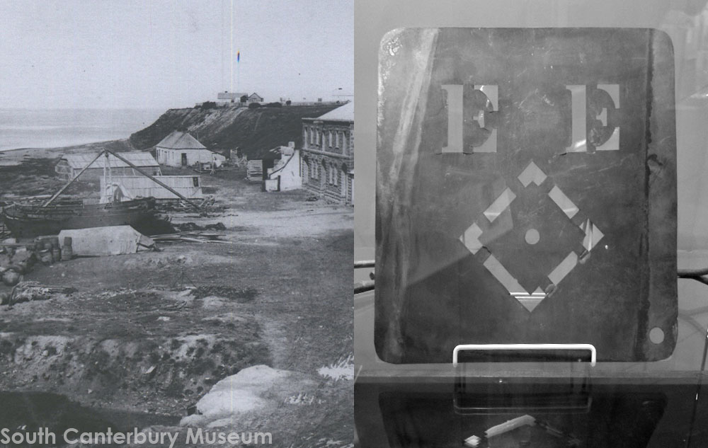
LEFT The home of George and Elizabeth Rhodes, the first European house in Timaru. This photo was taken years later after the surrounding buildings were built, including the Timaru Landing Services Building. RIGHT A branding iron used at the Levels run to brand sheep and wool bales photo taken of it in display at the SC Museum. In 1850s is was compulsory to brand sheep and to build sheep dipping facilities. This is where the area Washdyke gets its European name. Photography courtesy of Roselyn Fauth.
Some of the earliest Europeans to arrive in the Timaru area were sealers and whalers. It was a tough life and dangerous work.
Samuel Williams (Yankie Sam) and his friends, Long John Coffin and Billy the Bull were some of the whalers in Timaru. He went up to Akaroa to work on the Rhodes brothers farm and suggested to them that Timaru would make great sheep station country.
In 1851 the Rhodes brothers (George, William and Robert) established the Levels sheep run, becoming the area’s first long-term European inhabitants. When George and his wife Elizabeth arrived, they lived in the first European cottage on the shore in Timaru. They then moved to the Levels, a successful sheep run and by 1854 they had 13,200 sheep on the three runs and 4,000 on a forth, a 25,000 acre block at Otipua.
In 1855 James McKenzie was accused of stealing 1000 sheep from the Levels run. He escaped from jail twice before being eventually pardoned. The Mackenzie District was named after him.
Yankie Sam returned to Timaru in 1856 with his wife Ann and daughter Rebecca. They moved into the Rhodes cottage. Timaru's first European baby William Williams was born here, and his cradle was a gin case. The first the Timaru Herald was later printed in their kitchen.
Captain Henry Cain arrived in 1857, operating the first store (on behalf of HJ LeCren) and the first landing service. Cain was Mayor of Timaru from 1870-73.
Captain Belfield Woollcombe arrived in 1857 as the first magistrate. He lived by Waimātaitai Lagoon with his wife Frances, son and five daughters.

Early Timaru Book by F. G.. Hall-Jones. Cover and inside page: North Street to Maori Reserve. After A. Wills, 1848 (re-worded). An old map gives Pohatukoko, the same name as the northernAn old map gives Pohatukoko, the same name as the northernreef at the harbour, at the head of the bay on the site ofthe old native huts shown on Wills's map.
Read more: First Europeans settled in Timaru to Establish a Huge Sheep Station
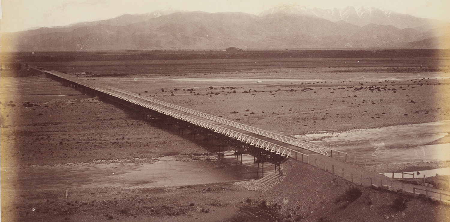
Rangatata Traffic Bridge. From the album: Scenes of New Zealand, circa 1880, Timaru, by Messrs. F. Bradley & Co. Te Papa (O.042416)
South Canterbury’s northern and southern boundaries were large, snow-fed rivers Waitaki and Rangitata that were difficult for early travellers to cross. Travelling by sea was easier.
1838 First mention of Timaru that we know of occurs in the journal of Octavius Harwood, who was foreman and clerk at Weller Brothers' whaling station at Otago.
The journal, which is preserved in the Hocken Library in Dunedin, commences on April 24, 1838.
""March, Thu. 28th. Schooner D.P. sailed for "March, Thu. 28th. Schooner D.P. sailed for Temurdu with Brown's gang on board-shipped two natives, Tomahawk and Rootie, for Brown's gang-issuedclothes for same. . ."forth, a 25,000 acre block at Otipua.

Mōkihi are among the few human-made objects to be depicted in southern rock art. Mōkihi display at Te Ana Ngāi Tahu Māori Rock Art Centre.

A 4m long sea saw that you can walk across was designed as a nod to the mokihi

A cargo box themed around the first European immigrant ship to sail direct from UK to Timaru. - Photo Roselyn Fauth

First Immigrant Ship to sail direct from UK to Timaru. Departed October 12 1858 and arrived January 14 1859. Image: R. Morris (2009). Courtesy South Canterbury Museum 2008/237.01
England was a wealthy country, but wealth was unevenly distributed.
Bread, potatoes and dried peas were the diet of the working class person. A loaf of bread cost half a worker’s weekly wage. So in the hope of a better life, they sailed to the new colony. This was 18 years after signing of The Treaty of Waitangi in 1840.
In 1858, the British government subsidized 50% of the fare for working-class immigrants traveling to New Zealand.
The Strathallan, carrying mostly English passengers with some from Scotland, Ireland, and Germany, left with 250 passengers, including 30 children under 10 years old.
Despite some hardships, like the loss of five children and two adults during the voyage, the Strathallan was considered fortunate compared to other immigrant ships.
On the way, a severe storm caused a broken top-sail, and passengers feared for their lives. There were no lifeboats.
After 90 days at sea, the Strathallan arrived in Timaru in 1859, but many passengers were disappointed by the barren, treeless coastal landscape. Some thought they would arrive at place the third of the size of London, but arrived to see only five houses in Timaru, including the Cains, Woollcombes and Williams and a small population of Maori. The settlers initially slept in Rhodes' woolshed until their houses were built.
A year later, 200 lived in Timaru raising their families and working as clergy, laborers, shepherds, and craftsmen.
By 1866 the population was around 1000.


Art History sign from the Aigantighe Art History Coastal Trail. Three signs are incorporated into the playground to help share stories through art. Artwork by Sue Tennant - Photo Roselyn Fauth
Between 1864 - 1892 30 Ships were wrecked or stranded off Timaru coastline.
6 x Barques, 6x Brigantines, 4x Iron Ships, 3x Ketches, 6x Schooners, 2x Steamers, 2x Brigs and 1 x Steamship.
22 Ships Wrecked, 8 were refloated. 100 Lives were saved by Timaru, Volunteer Rocket Brigade, and 43 Lives saved by Alexandra Lifeboat Crews. 15 People died.
The harbourmaster kept a lookout during storms. They could give ship crews instructions by hoisting flags, and fire a signal gun to call for crews to race to the rescue. Safety and effiency of handling cargo and passengers had to be improved. So the locals funded their own harbour. It was only one of two independantly owned ports in the country. The Port provided huge opportunity to Timaru and South Canterbury. It also impacted the way sediment moved up the coast. From 1880s sand built out from these Caroline Bay cliffs and created a new sandy Caroline Bay.

The Ben Venue (left) and City of Perth (right) ships in Caroline Bay. The Ben Venue was wrecked at Caroline Bay in May 1882. The city of Perth collided with the wreckage and also ran aground but was eventually refloated carrying over 5000 sacks of milling wheat from newly broken in farms of the area. Photographer J Dickie Courtesy South Canterbury Museum 2014/056.01
In the 1880s ships were powered by sail. If the sea was rough, but there was little wind, it was hard for ships to sail away from the coast to safety.
On top of this, Timaru had no harbour, and ships had to use row boats to move cargo and passengers.
But, if the ships were anchored too far out to sea to it impacted the efficiency.
In the 1860s, Morris Corey and Robert Boubius (Boatmen from Deal) drowned while attempting a sea rescue.
In 1864, the Alexandra lifeboat arrived in Timaru to assist when heavy surf made it too dangerous for regular boats.
In 1867, the Volunteer Timaru Rocket Brigade was established with the arrival of rockets from England. In 1868, control of the beach was passed to the Timaru Gladstone Board of Works to undertake harbor works. In 1869, Duncan Cameron, a member of the lifeboat crew, drowned when the boat capsized.
Captain Alexander Mills served as the harbor master, lighthouse keeper, and pilot in Timaru from 1866 to 1882. During his tenure, there were 28 shipwrecks, and he frequently clashed with the Harbour Board over mooring decisions.
The harbourmaster kept a lookout during storms. They could give ship crews instructions by hoisting flags, and fire a signal gun to call for crews to race to the rescue.

Section from a photograph taken by the Burton Brothers circa 1882; of the "Ben Venue" stranded. In the distance you can see the Caroline Bay coastline before the sand started to accumulate. Te Papa (C.025205)

Timaru Volunteer Rocket Brigade. Photographer William Ferrier c1882. South Canterbury Museum 0844
How the Illustrated London News saw rowing lifeboats in action. heartheboatsing.com/for-those-in-peril-on-the-sea/

A lifeboat crew rowing to rescue shipwrecked sailors. published 1893-02-11 The New Zealand Graphic and Ladies Journal, 11 February 1893, p.121 - New Zealand Graphic; Wright, Henry Charles Seppings, 1849-1937 - Auckland Libraries Heritage Collections NZG-18930211-0121-01

The South Canterbury Museum has an exhibit that includes the Benvenue Bell and medals, the rocket brigade lifesaving launch and the canon that summoned the rocket brigade. Photograpy courtesy of Roselyn Fauth.
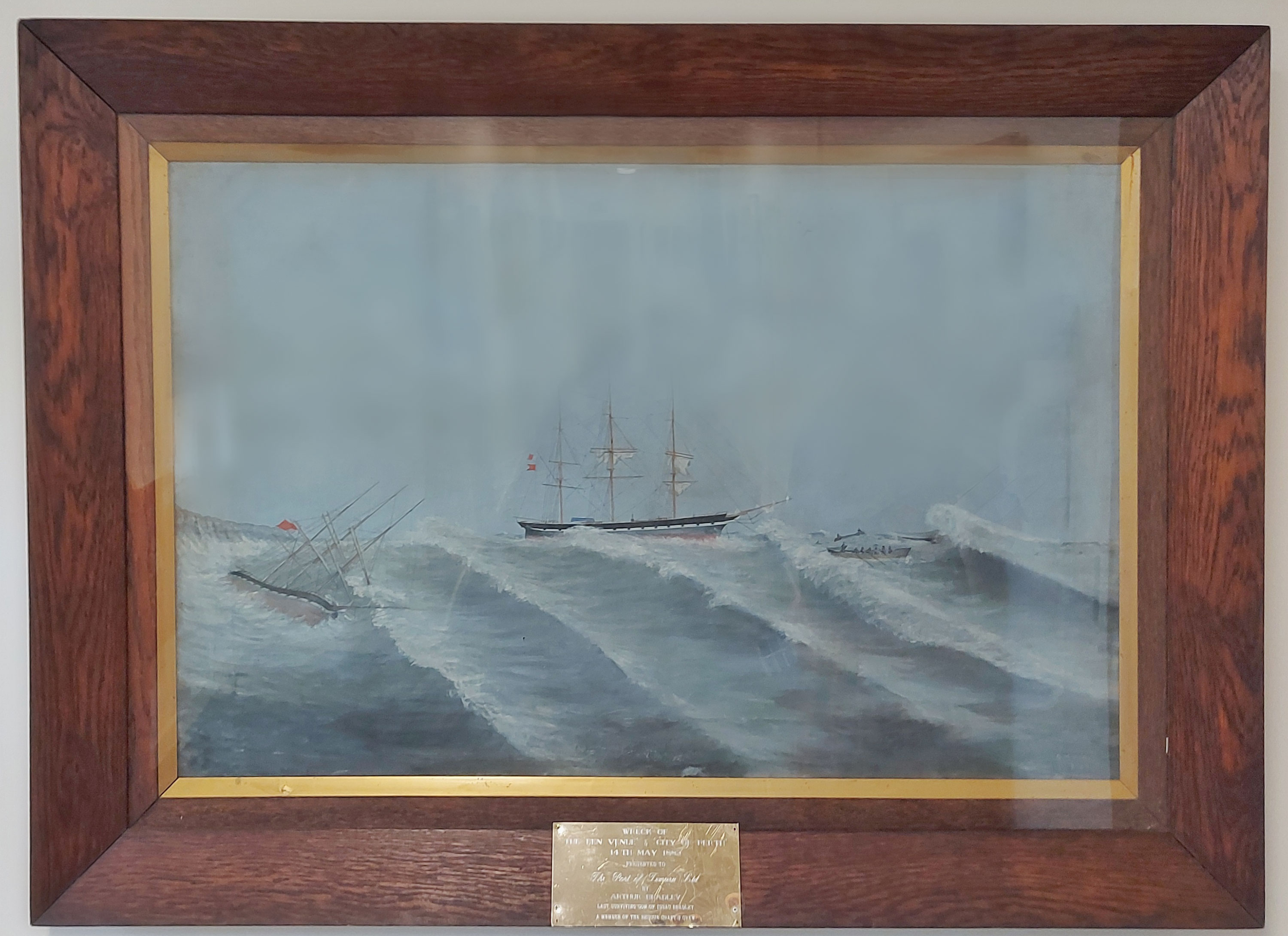
The large painting (about four feet in length) of the wreck of 'City of Perth' and 'Ben Venue' at Timaru hung for many years in the Farmers tearooms and now the painting is at the Port Company Offices, Timaru at Marine Parade. The plate below the painting read : The Wreck of the Ben Venue and City of Perth 14 th May 1882. Presented to The Port of Timaru Ltd. By Arthur Bradley. Last surviving son of Issac Bradley a member of the rescue crafts crew. Located at Prime Port - Photo by Roselyn Fauth.

Anchor that has been gifted to CPlay to incorporate.


The Blackett Lighthouse was originally on the Terrace, No. 7. It was later relocated to the corner of Te Weka Street and Benvenue Ave, and then again to the Benvenue Cliffs. It is a Category II structure and the Historic Places Trust. LEFT: The Lighthouse at its current site in 2021. Courtesy of Roselyn Fauth. RIGHT: Timaru's lighthouse being relocated 1980. Courtesy of South Canterbury Museum 2014/107.73
In 1878, Blacketts Lighthouse was constructed on Le Crens Terrace. It was supposed to be at Patiti Point, but because only a wooden lighthouse was on offer, it wasn’t seen as a good idea to have it and its kerosine lantern next to the towns ammunition supply!
John Blackett, a Government Marine Engineer, designed the Timaru lighthouse, which was 1 of 14 across the country.
The three-story, kauri timber lighthouse with a kerosene lamp was first lit in July 1878.
The the light was powered by gas in 1890, then electricity in 1920. It was decommissioned in 1970, the same year, that work began on the construction of the Southern breakwater.
It was initially situated on the Terrace, then moved to the corner of Te Weka Street and Benvenue Ave, and finally to the Benvenue Cliffs in 2010.
The lighthouse is a Category II Historic Place.
John Blackett, despite his involvement in lighthouse construction, was opposed to the development of the Timaru breakwater and criticized it as a "complete fiasco." He expressed concerns on shingle buildup and coastal erosion.
Some 1000 people protested against his remarks by parading an effigy of him down the main street to the breakwater and then blew it up!
145 years later we can use our own lens to reflect on decisions made in the past to see how they impacted Timaru today.
While Blackett was right, and Timaru would see rapid changes to the coastline, it also needed a efficient and safety harbour for the area to prosper.
This lighthouse is a reminder of the role of shipping and coastal transport in Timaru’s social and economic development.

A set of the original plans for construction of the Timaru lighthouse hand drawn by John Blackett circa 1877. Courtesy South Canterbury Museum 2004/070.37

Section of the HMS Ringarooma cruiser in Timaru Harbour where you can see the Blackett Lighthouse up on Le Cren Terrace 1895-02-23 - Auckland Libraries Heritage Collections NZG-18950223-0180-01

A art history sign features Blackett story by the lighthouse. Michael Armstrong (1954). Blackett on the Breakwater, 2019. Acrylic on canvas. Friends of the Aigantighe Collection, Aigantighe Art Gallery, 2019.24.1


If we didn't sort out our harbour, the ships would go elsewhere. The surfacing design was inpsired by the views from a plane over the patchwork of our areas farms reaching into the MacKenzie and lakes - Photo Roselyn Fauth

Wool, grain, and frozen meat were some of the areas key exports that relied on a safe and efficient harbour. - Photo Roselyn Fauth

William Ferrier (1855-1922), Breakwater Timaru Running a Southerly Gale, 1888, Oil on canvas - Aigantighe Art Gallery Collection 2002.10
Since the 1840s Timaru became a hub for coastal trade and the landing service enabled the town started to grow. However 28 shipwrecks in 16 years was a major problem. The safety and efficiency of handling cargo and passengers had to be improved.
In the 1860s J.M. Goodall, engineer, for the Harbour Board worked on plans for the Harbour. 1878 Work Began to Construct Southern breakwater near the foot of Strathallan Street was talked about as the boldest work that has been undertaken in New Zealand at that time.
The locals funded their own harbour. It was only one of two independently owned ports in the country.
1881 The construction of the railway cause shingle to accumulate in front of the Landing services, and they closed down.
1883 Timaru had one wharf 880 feet long and was a success.

William Gibb (1859-1931) Timaru Harbour, 1888, Oil on canvas - Aigantighe Art Gallery Collection 2002.10
1900 Grain merchant and miller, William Evans persuaded the rate payers to loan £100,000 to what is now known as the Eastern extension. This was to combat the shingle that was filling the shipping channel. It was completed in 1915 with 432,207 tons of blue stone that was quarried from Centennial Park.
The moody wharf was built in 1908, and a wharf for fishermen was built 1911.
The Port provided huge opportunity to Timaru and South Canterbury. It also impacted the way sediment moved up the coast. From 1880s sand built out from these Caroline Bay cliffs and created a new sandy Caroline Bay.
Imagine after all the hard work of breaking in farms and establishing products to trade, and then worrying the ships might go else where and impact the cost to ship.


South Canterbury Jubilee dinner at Timaru, 1909. Shows guests at a dinner held in the Drill Hall, with men and women seated at long tables. Flags hang along a wall. A banner compares import, export, mutton, and wool statistics of 1859 and 1909. Photographer unidentified. Toned silver gelatin print. - natlib.govt.nz/338563

It also contributed to the rapid change othe coastline as you can see in these two comparison maps.

1902 Bay first formed after creation of port breakwaters. The motion of the waves turned the shingle to sand. The area was decided to be created into a “European style beach resort” from 1902.
This is the only sandy beach between Oamaru and Banks Peninsula.
The borough council leased the new foreshore from the harbour board in 1902 and created a European-style beach resort.
Many hours of voluntary labour went into creating a promenade and pleasing recreational facilities.
Tea rooms, a hot-water swimming pool and a band rotunda were built.
A ‘sound shell’ for concerts replaced the rotunda in 1937.
Later, a piazza was built to improve access to the bay from the top of Bay Hill.
Christmas carnivals have been held at Caroline Bay since 1911, attracting thousands.
In 2020, the area the beach had extended by 34 hectares.
There has been a continual progression of beautification and development on the Bay over the decades, particularly as the beach has continued to extend seaward providing greater areas for lawn and facilities.

By sharing stories about the Caroline Bay and wider area we can
- Inspire imaginative play.
- Help people learn about where they are from, to better know themselves.
- To reflect on the past with todays lens to make better choices for the future.
- Caroline Bay is the only sandy beach between Oamaru and Chirstchurch, and so as well as playing in nature, we offer an amazing new playground to offer fun for a range of ages, stages, sizes, abilities and interests.
We hope you love the new playground too.

Detailed information and research that inspired the playground design
- Copyright
- Timaru's name
- Caroline Bay Timeline
- A Place for Gathering
- Caroline Bay Geology
- Creation Stories
- Waka
- Mahinga Kai / Mahika Kai
- Moon Phases & Maramataka
- Māori Park said to be the most historic place in Timaru
- Pohatu-koko and the Whalers
- Te Rehe
- The Strathallan
- Pests Being Pests
- Early European Settlers
- Variations on the Spelling of Timaru
- The Ship Graveyard
- Timaru's Early Exports at Threat from Wrecking of Ships
- Shipwrecks
- Captain Alexander James Mills (1833-1882)
- Alexandra Lifeboat
- Signal Gun - Gunnard
- Timaru Landing Service's
- Blackett Lighthouse
- Timaru Port
- New Sandy Caroline Bay
- Changing Coastline
- The Riviera of the South
- Play at the Bay for Over a Century
- Playground Upgrade
- Timeline of Events that Inspired CPlay


