CPlay Projects Supporters and Contributors

Please enable the javascript to submit this form

 CarolineBay Eliot Whately 1874

The view of the Caroline Bay coastline in 1874. This is a section of a watercolour painting by Sir Eliot Whately (1841-1927). Depicts Caroline Bay, Timaru in October 1874. nla.gov.au/nla.obj-138581877


While tides and currents gradually change and shape our coastlines, the intervention of man-made structures also plays a significant role in accelerating coastal evolution and erosion.

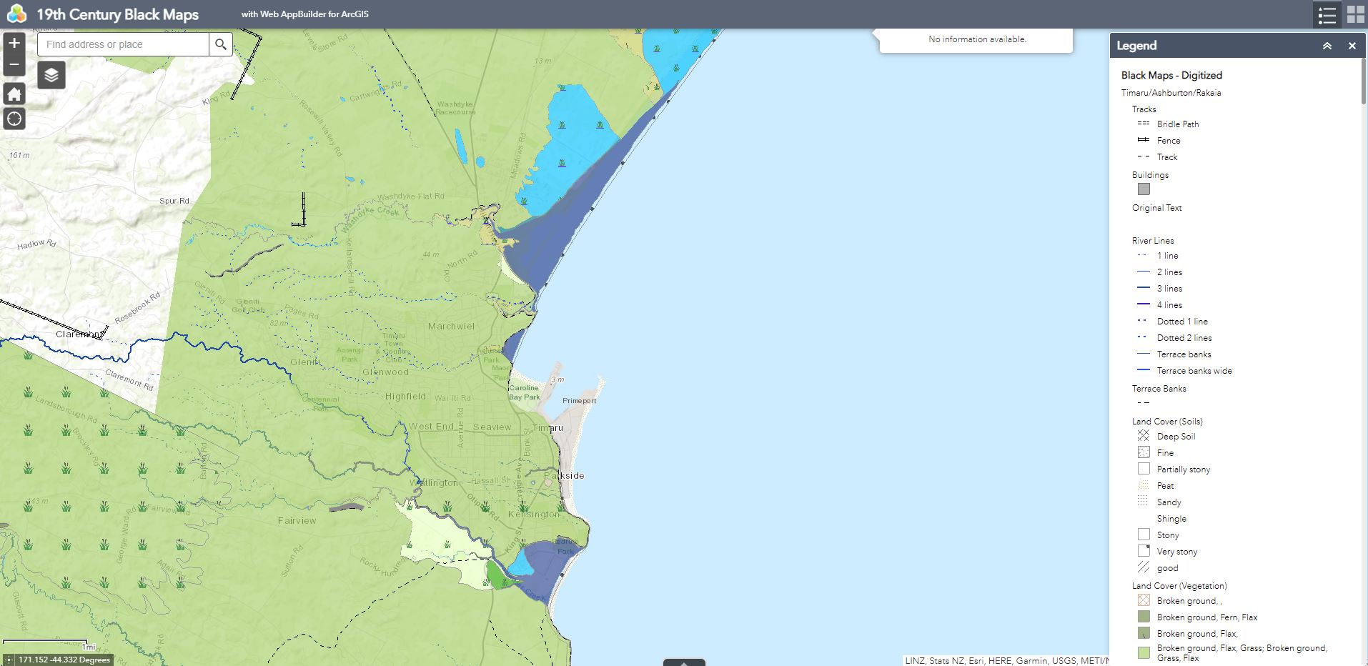
The construction of the port and breakwater interrupted the northward flow of sediment along the Timaru coastline. Gravel was trapped south of the port and sand was pushed into Caroline Bay, causing the land in these areas to grow out towards the sea. To the north, beaches from Waitarakao to the Opihi River were conversely starved of sediment, resulting in an increase in erosion at the cost of land, coastal lagoon area and biodiversity.

Timaru Port provided a huge boost to the economy and resulted in the formation of Timaru’s iconic Caroline Bay beach by re-directing the flow of sand into what was previously an open bay with coarse gravel beach.

However, as Blackett predicted, the port development interrupted the flow of gravel along the coast resulting in a rapid increase in erosion to the north of Timaru. The increased erosion has had many negative impacts on the land and the environment, particularly affecting biodiversity and the once plentiful mahinga kai areas used by Māori.


2622 01 012A

J. S. Browning, (1831 – 1909), Timaru Looking North West, 1860, file copy print, Hocken Collections, Uare Taoka o Hākena, University of Otago.


57173 max Sketch of Caroline Bay Timaru ENorman ShowsWaiitiRd

Sketch of Caroline Bay, Timaru By E. Norman - Copied from original held in South Canterbury Historical Museum, Timaru, 1870


WashdykeLagoonTimaruNZ October187

Next time you are at Dashing Rocks compare this painting with the view today. Note the changes to the coastline. This is a section of a watercolour painting by Sir Eliot Whately (1841-1927). Depicts Dashing Rocks bay looking out to Waitarakao Washdyke Lagoon, Timaru in October 1874, commencement of ninety miles beach. Courtesy National Library of Australia nla.gov.au/nla.obj-138582273


MA I470105 TePapa 90 Mile Beach Timaru cropped

90 Mile Beach, Timaru, New Zealand, by Burton Brothers. Te Papa (C.014424)


Timaru Harbout General Chart Timaru Sir John Coode cropped

Timaru Harbour, Province of Canterbury : general chart of Timaru and adjoining coast by Sir John Coode showing works recommended by Sir John Coode, August 1875. (from Patiti Point to Washdyke Lagoon). The proposed works are shown by red colour. timdc.pastperfectonline.com/DCEC5B88-61FE-4949-80EC-525377755260


Miscellaneous Plans Borough of Timaru South Canterbury 1911 TNBrodrick Chief Surveyor Canterbury R25538727 CarolineBaySection

In this map you can see the Caroline Bay in 1911. Miscellaneous Plans - Borough of Timaru, South Canterbury, 1911 - T.N. Brodrick, Chief Surveyor Canterbury  ndhadeliver.natlib.govt.nz/IE31423732


WUHOO CPlay KaiHunt CarolineBay 220302 NoticeChange Map


WUHOO CPlay KaiHunt CarolineBay 220302 NoticeChange MapToday


WUHOO CPlay KaiHunt CarolineBay 220302 NoticeChange

In 1929, the 400m long Memorial Wall was built with Bronze plaques feature the battlefield names where kiwis served in international wars. This was also the sea wall at the time.


WUHOO CPlay KaiHunt CarolineBay 220302 NoticeChange

In 2008 the sandy bay was more than 400 m northeast of the memorial wall and the sand will continue to build out until it finds an equilibrium.

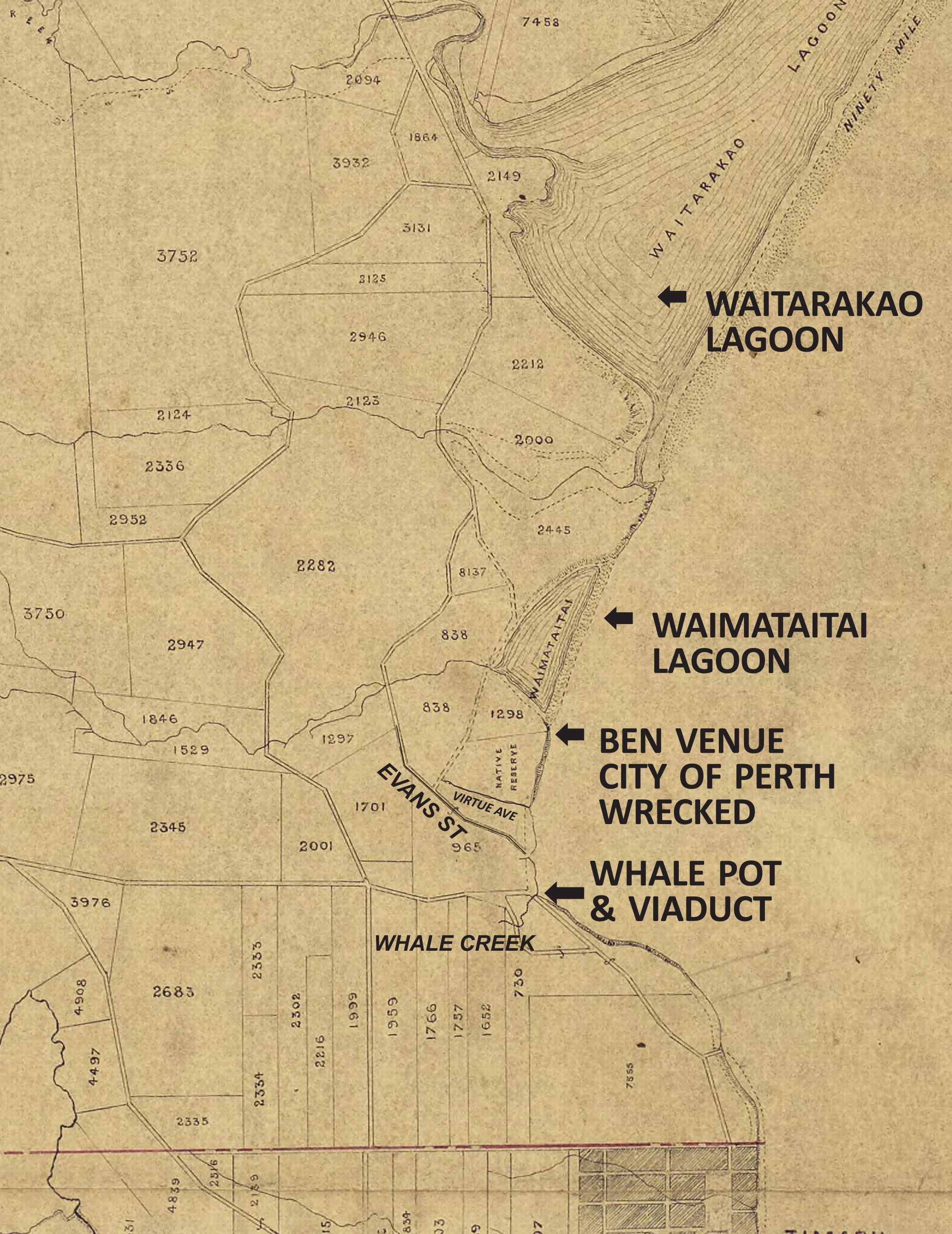
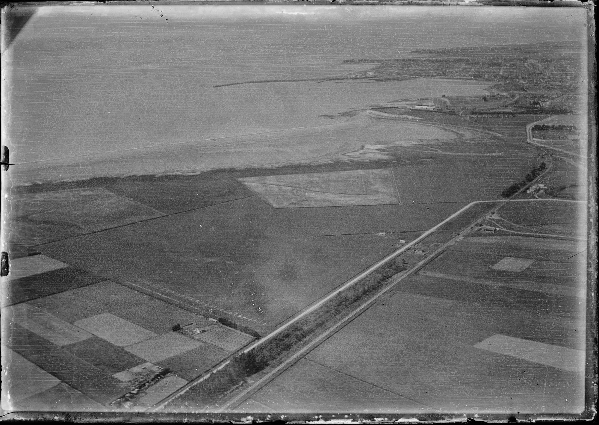
In comparison the coast further north is starved of sediment, where for example Waitarakao Washdyke Lagoon in 1881 was 253 hectares, but now is about 20. This was one of 15 fishing easements set aside in 1868 by the Native Land Court in to allow Ngāi Tahu to continue the practice of mahinga kai. For the longest time it had the perfect mix of saltwater and freshwater, allowing a diverse range of native species to thrive there. Now a combination of the port, industrial area, SH1 and railway prevent the lagoon from expanding, while the sea pushes the gravel barrier ever inland.


Aerial view of Timaru, showing Caroline Bay, harbour and town.

Aerial view of Timaru, showing Caroline Bay, harbour and town by Frank Douglas Mill - 1927-1937 - Auckland Libraries Heritage Collections FDM-0690-G


CarolineBay ChangingCoastLine

View from above, the Waimātaitai lagoon has drained and been reclaimed as Ashbury Park with an athletics track. Sand is accumulating in Caroline Bay and tennis courts, grass prominade and caretakers house are established.


CPLAY CarolineBayFromAbove

ABOVE Arial view looking down to Caroline Bay and the Port of Timaru 2019  mapviewer.canterburymaps.govt.nz


CPLAY CarolineBay Map 210317

LEFT The brown lines show the changes to the mean sea level since 1926. Graphic courtesy Roselyn Fauth 2019 with assistance from the South Canterbury Museum. RIGHT One of the mean tide markers along the North to South promenade at Caroline Bay.  Photograph courtesy Roselyn Fauth 2019


Aerial view of Timaru coastline with harbour in background, approaching from the north.

Aerial view of Timaru coastline with harbour in background, approaching from the north. 1927-1937. - Auckland Libraries Heritage Collections FDM-0099-G


Auckland Libraries Heritage Collections FDM-0690-G, F. Douglas Mill Collection

Credit is to Auckland Libraries Heritage Collections FDM-0690-G, F. Douglas Mill Collection.


WUHOO CPlay KaiHunt CarolineBay 220302 NoticeChange

One of the ways you can investigate is visiting 9th Century Black Maps - Check out that huge lagoon and wetland that used to be where Washdyke industrial area is today... you can also see the Waimataitai wetland that used to be at Ashbury Park and the changes at Otipua Wetlands too! https://www.arcgis.com/apps/webappviewer/index.html?id=bec5eceea7514735b73bbe9e8082371f
 
 
Timaru Coastal Changes
 
Here you can see the Timaru Coastline, comparing the digitized survey maps (that were created 1848 - c.1870s) to 2022. The surveys were carried out for the legal purchase and sale of land parcels, initially under the administration of the Canterbury Association, which was founded in London 27 March 1848 in order to establish a Church of England settlement in New Zealand. The historic survey maps are a crucial source of information showing the Ngāi Tahu relationship with the landscape of Te Waipounamu. The Black Maps are fascinating objects that help bring to life the story of pākehā exploration and the development of Canterbury.  https://apps.canterburymaps.govt.nz/BlackMaps
This gives an insight into traditional areas of mahinga kai (sites of significance to Māori for food gathering) such as wetlands, lagoons, and estuaries before they were modified. - https://mapviewer.canterburymaps.govt.nz/?webmap=0db87348adef4595a91994a3dc85cefe&extent=1457673.4475%2C5078749.6304%2C1476018.3343%2C5087320.1322%2C2193
 
Waimātaitai was a hāpua (lagoon) situated near the Tīmaru foreshore, renowned as an important source of mahinga kai. In 1880 Hoani Kāhu from Arowhenua described Waimātaitai as “e rauiri” (an eel weir) where tuna (eel) and inaka (whitebait) were gathered. This saltwater lagoon was eventually lost in 1933 due to changes in sediment drift caused by the creation of the Port of Tīmaru.
 
Waitarakao (Washdyke Lagoon) is the brackish shallow coastal lagoon south of Tīmaru on Kā Poupou-a-Rakihouia (the South Canterbury coastline). Waitarakao was a renowned kāinga mahinga kai (food-gathering area) for local Ngāi Tahu, with foods gathered there including tuna (eels), inaka (whitebait), patete (fish), and kōareare (the edible rhizome of raupō). Hoani Kāhu from Arowhenua described Waitarakao as an example of where a significant mahinga kai resource has been degraded. He stated: “Now the Europeans go there and destroy large numbers of eels for ‘sport’, but do not use them. In former times our whata (eel weirs) used to be full of food, but now we do not whata because we have nothing to put in them, through everything being taken from us by the Europeans.”
 
 
00001 5 59.pdf.00001
 
The Sheltering Place: Yankee Sam of Timaru - whaler, settler, publican (26 Jul 1975). Aoraki Heritage Collection, accessed 23/06/2023, https://aorakiheritage.recollect.co.nz/nodes/view/1096
 
 
1938 CarolineBay ChangingCoastline 230630 takenFeb Taken 1938 Number SN86
1938 - Caroline Bay arial photo taken 1938 - Retrolens-Linz-Survey Number: SN86
 
1956 CarolineBay ChangingCoastline 230630 takenFeb Taken 1956 Number SN803
1956 - Caroline Bay arial photo taken 1956 - Retrolens-Linz-Survey Number: SN803
 
1967 CarolineBay ChangingCoastline 230630 takenFeb Taken 1967 Number SN1965
1967 - Caroline Bay arial photo taken 1967 - Retrolens-Linz-Survey Number: SN1965
 
1982 CarolineBay ChangingCoastline 230630 takenFeb Taken 1982 Retrolens Linz Survey Number SN8032
1982 - Caroline Bay arial photo taken 1982 - Retrolens-Linz-Survey Number: SN8032
 
1982 CarolineBay ChangingCoastline 230630 takenFeb Taken 1982 Retrolens Linz Survey Number SN8032
1982 - Caroline Bay arial photo taken 1982 - Retrolens-Linz-Survey Number: SN8032
 
1999 CarolineBay ChangingCoastline 230630 takenFeb Taken 1999 Number SN12543
1999 - Caroline Bay arial photo taken 1982 - Retrolens-Linz-Survey Number: SN12543

Noticed damage, graffiti, rubbish etc?  Please contact Timaru District Coucil via their "Snap, Send, Solve" app or form: timaru.govt.nz/fix-it

For urgent attention phone Customer Services 03 687 7200.

You can still reach our volunteers via email, just keep in mind we are not actively monitoring our messages, so thank you for your patience if we take some time to respond. info@cplay.co.nz

LOCATION
1 Virtue Ave, Caroline Bay, Timaru
(Off SH 1, Evans St).

OPEN 7 days / 24 hrs 
FREE ENTRY

©2020-2024 CPlay and  Website Sponsored by Cloake Creative   Images are subject to copyright by various contributors - for the sole use of CPlay.